 Edwin Nand
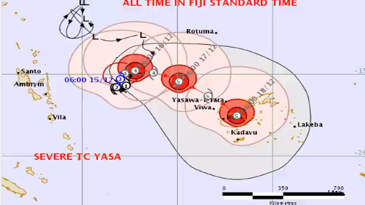
Tropical Cyclone Yasa is forecast to pass between the two main islands as a category four or even a category five system by Thursday based on current projections.
Senior Forecaster at the Fiji Meteorological Services Steven Meke says TC Yasa will first affect the Yasawa Group.
“Late on Thursday, we should expect it to be just to the North West of Yasawa and we should be expecting some damaging gale-force winds to affect the Yasawas, the Western parts of Viti Levu, the Northern parts of Vanua Levu and parts of the Lomaiviti Group. On Friday, on this track the system is expected to lie over Lomaiviti Waters. If that happens, we should expect damaging to hurricane-force winds over the whole of Fiji, especially over the Lau Group, Vanua Levu – that is Taveuni and even Kadavu.”
From tomorrow evening, winds will pick up to about 55km/ph gusting to about 80km/ph and continue to increase as the cyclone nears Fiji.
Periods of heavy rain will also be experienced over most parts of Fiji from late tomorrow.
By late Thursday, as TC Yasa comes closer to the Fiji Group, wind speeds will increase to 175 km/ph gusting to 250 km/ph.
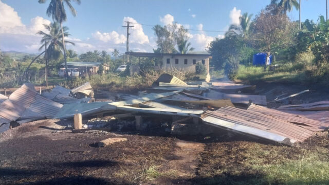
Meke adds the gale force winds will be very destructive, breaking powerlines, damaging farm lands and possibly damaging houses and weak structures.
“Expect a lot of damage to root crops, houses and once the centre moves closer we should expect some very destructive winds. So if the centre is close to any particular area, it will be destructive even to well built houses to pole line could be vulnerable and roads could be flooded.”
The Nadi Weather Office also advises there could be severe storm surges in coastal areas of Northern Viti Levu, Nadi, Ba, Rakiraki and possibly Tailevu.
Storm surges will also be felt in Northern Vanua Levu along the coastal areas of Bua, Seaqaqa, Udu point as well as Yasawa, Mamanuca and nearby areas.
Tropical Cyclone Yasa currently a category three, was located about 600 kilometres West Northwest of Nadi at 6am.
It is moving at about nine kilometres per hour completing its loop before heading towards the Fiji Group.
It now has sustained winds of up to 146 km/ph close to its centre, increasing to 166kmph.
It is expected to come closer to the Fiji Group in the next two days, however adverse weather will be felt by parts of Fiji in the next 24 hours.
“We expect the track – the centre just to be just to the North West of Yasawa on Thursday morning around 9am, at around 9am Friday, we should expect the centre to be around the Lomaiviti Group then on Saturday, and we should expect it to be exiting the Lau Group.”
The Fiji Meteorological Services confirms the slow-moving system is still gaining strength having made a slight change in direction, as it now moves in an East Northeast direction.
A heavy rain warning is now in force for the Yasawa and Mamanuca group, eastern half of Viti Levu, Vanua Levu, Taveuni and nearby smaller islands.
A heavy rain alert is now is force for the rest of the Fiji group.
Flash flood alert remains in force for the low lying areas and areas adjacent to small streams for the interior of the main island; upper Nadarivatu, Monasavu, upper Wainimala.